Blarg Papers
Volume 1 · Issue 1 · May 18, 2026
From Blarg Papers

Explore more research, products, and the wider Blarg portfolio at blarg.studio.

Visit blarg.studio
Feature · Heritage · Caribbean

Preservation and Resilience

How imperialism and slavery impacted the heritage and cultural landscape of Dominica.
The decaying Sugar Age sites in Dominica paint a story of subjugation. Yet overgrowing these sites are the natural landscape, quite literally reclaiming Dominica by incorporating the material remains of a once dominant colonial order.

Chapter OneDiscovery?

The island the maps later called Dominica was already named, already inhabited, already part of a regional trade network long before the framing of European discovery was applied to it. The Kalinago people called it Waitukubuli, meaning tall is her body, and held the island as part of a larger Caribbean world that moved goods, ideas, and people between the Lesser Antilles for centuries before contact. The arrival of European ships into that world did not initiate Caribbean history. It interrupted it.

The framing of discovery has done a particular kind of damage in the Caribbean, and Dominica is where some of that damage is most legible. The Kalinago manifested over generations into a distinctive group with its own political organization, language family, and territorial sense. Early European chroniclers read that distinctiveness as hostility and used the reading to justify what came next. The result, as Honychurch and others have argued, was to unnecessarily separate groups of people while excluding the Kalinago from their crucial role in developing the cultural landscape that imperial cartographers would later claim to have authored.

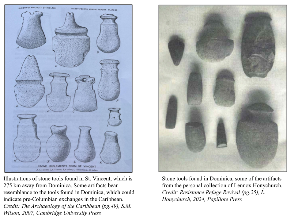
What the archaeology now makes plain is that Waitukubuli was an active node, not a blank slate. The earliest layers at the sites discussed in the next section show pre-Columbian occupation with material connections to neighboring islands, and the cultural landscape the Europeans encountered was already legible as a landscape, with paths, fishing grounds, garden sites, and gathering places. The question of whether Columbus discovered Dominica is, in this light, the wrong question. The right one is what was already there, who was keeping it, and how that work continued underneath every empire that came after.

The Kalinago manifested into its own distinctive group and were mistaken for a separate identity, unnecessarily separating groups of people while excluding the Kalinago from their crucial role in developing the cultural landscape of Dominica.

Chapter TwoDominica, the Trading Colony

Before Dominica became a Sugar Age colony it was a trading colony, and the difference matters. Trading colonies are places where exchange happens on terms at least partially set by the local population. Plantation colonies are not. The transition from one to the other in Dominica is one of the central stories the cultural landscape still tells, and the archaeology at La Soye is one of the clearest places to read it.

La Soye is a complex of four sites at Woodford Hill in Saint Andrew Parish on the northeast coast, excavated by a multi-institution team drawing researchers from Leiden University, Northwestern University, and the University of South Florida. The material recovered there documents pre-Columbian inter-island trade that predates European arrival and continues into the early contact period. Sherds, faunal remains, and lithic material from La Soye place Dominica firmly inside a regional Caribbean trade system that did not require European mediation to function.

What La Soye 1 through 4 also document is the slow encroachment of European presence onto that system. The sites contain layers of contact-era material that show the trading colony posture lingering well after the political map of the Caribbean had been redrawn. For a long while, exchange continued on something close to the original terms. Then it did not. The shift from trading colony to plantation colony was neither immediate nor consensual, and the archaeological record is the place where the timeline of that shift is being slowly, carefully reconstructed.

Fort Shirley and Scotts Head show how Britain had a complex strategy covering fortification against Kalinago raiders and rebel slaves while displaying military dominance.

Chapter ThreeBattle of the Empires

Dominica sits between Guadeloupe to the north and Martinique to the south, and that geography placed it in the path of every imperial contest in the eastern Caribbean for three hundred years. The Treaty of Saint Christopher in 1660 formally recognized Kalinago sovereignty over Dominica and Saint Vincent, attempting to create a neutral zone between French and British holdings in the region. Planters of all four major imperial powers, British, French, Dutch, and Spanish, proceeded to ignore that recognition almost immediately and almost completely.

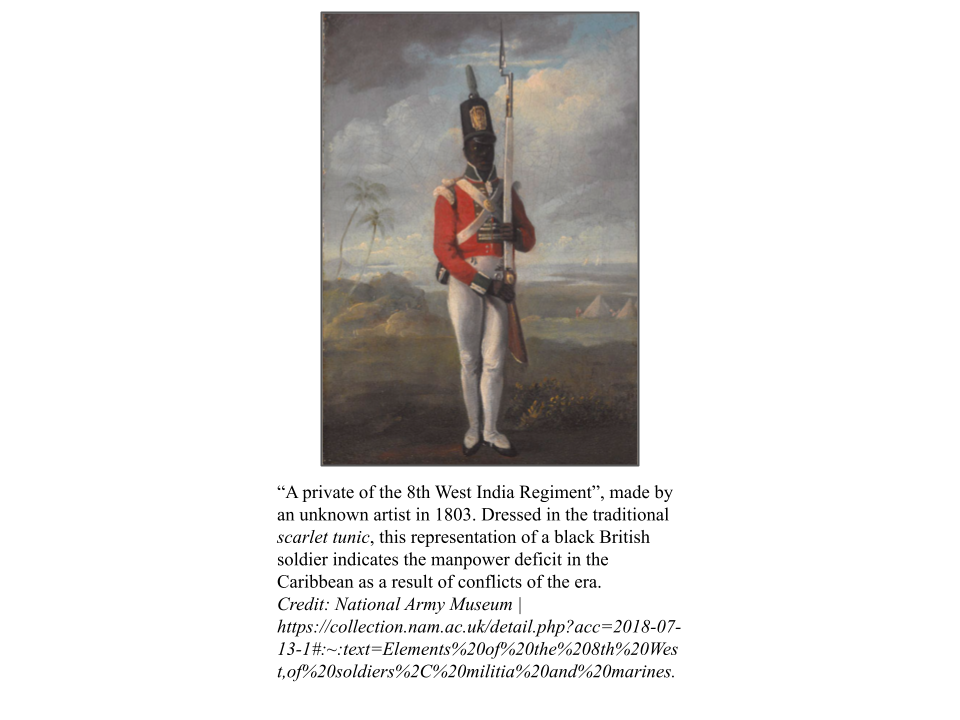
The military architecture of that ignoring is still on the landscape. Fort Shirley sits on the Cabrits Peninsula at the island's northwestern tip, a British garrison complex that controlled the channel between Dominica and Guadeloupe. Scotts Head guards the southern approach, the place where the calm Caribbean meets the open Atlantic. Together they bracket the island, and together they tell a particular story about the British strategic posture during the long eighteenth and nineteenth centuries. The fortifications were not only outward facing. Britain had a complex strategy covering fortification against Kalinago raiders and rebel slaves as well as against the imperial rivals across the water.

The structures are still there because they have been intentionally preserved as heritage assets, not because they survived neglect. That preservation choice is itself part of the story. Fort Shirley today reads as a heritage site, a public park, a place a visitor walks through. The eighteenth century military function and the twenty first century interpretive function are layered on the same stone, and the cultural landscape carries both layers at once.

Chapter FourRise and Plateau of the Sugar Age

The Sugar Age transformed Dominica from a trading colony into an agricultural powerhouse in an immensely short timespan. Land that had been worked under one regime of exchange was repurposed as plantation, and the cultural landscape took on the morphology of a sugar economy: terraced slopes, mill ruins, road networks oriented toward shipping points, and population centers arranged around plantation infrastructure rather than around the older coastal trade sites.

That transformation was driven by enslaved labor. The demographic record is unambiguous on this point. The plantation economy in Dominica, as across the eastern Caribbean, depended on the forced labor of African and African-descended people, and the violence required to maintain that dependence shaped both the human and the physical landscape. Maroon communities formed in Dominica's mountainous interior, drawing on the terrain that made the island difficult to fully police. The Indian River corridor, and the inland watersheds it drains, became one of the routes by which Maroon settlements communicated, traded, and at moments coordinated.

Slave and Maroon rebellions ravaged European colonies across the Caribbean during the Sugar Age, and Dominica was part of that pattern. The archaeological record of the period is therefore not the record of an unbroken plantation system. It is the record of a system that was constantly being contested from inside. The cultural landscape that emerges from that period has plantation infrastructure as its most visible layer, but it has resistance as its substrate, and the substrate is what survives.

The phrase colony within a colony is used by Lennox Honychurch to describe the Kalinago Territory. Dominica itself was a territorial possession of the British empire; carving out a space for the Kalinago to coexist was essentially the inception of a new colony.

Chapter FiveKalinago Territory and Decolonization

The Kalinago Territory exists today as a roughly 3,700 acre reserve on the eastern coast, formalized under British administration and continued under the Commonwealth of Dominica. Lennox Honychurch's framing of the Territory as a colony within a colony captures what is structurally singular about it. Dominica itself was a territorial possession of the British empire, and carving out a separate space for the Kalinago to coexist was essentially the inception of a new colony, a smaller jurisdiction whose terms of recognition were set externally and whose boundaries were drawn on someone else's authority.

The colonial administrative history of the Territory is well documented through the surveys carried out by Hesketh Bell and his successors. What the surveys do not capture, and what the cultural landscape does, is the long quiet work of continuity. Kalinago presence on Dominica did not pause and resume at the convenience of British administrators. It continued throughout, often outside the visibility of the colonial record, and it is one of the most direct sources of contemporary Dominican identity.

The road to independence ran through specific incidents. The La Plaine tax riot of 1893 is one of them. The dispatch of Buffalo Soldiers and other imperial troops to enforce colonial order in the Caribbean is another, and the Bob Marley line that gave a later generation a way to name that pattern is yet another. The Commonwealth of Dominica was inaugurated in 1978, and independence was less an arrival than a recognition. Dominicans were already, by then, becoming a people in their own right, and the landscape had been recording that becoming for centuries.

ConclusionReclamation of the Cultural Landscape

The thesis the capstone arrives at is a quiet one. The process of Dominicans becoming a people in their own right is reflected throughout the landscape, and the raw history of contact, conflict, and resistance is embedded in the archaeological record. Heritage preservation, on this reading, is not a matter of freezing a moment. It is a matter of keeping the record legible so that the becoming can continue.

Three vectors carry that work forward in present day Dominica. Community archaeology, exemplified by the continued multi-institution work at La Soye, brings local stakeholders into the interpretive process rather than treating them as subjects of study. Heritage tourism, organized around the forts, the Kalinago Territory, the river systems, and the Sugar Age ruins, channels economic value back into the landscape that produced it. And policy work, both at the national level and through partnerships with bodies such as UNESCO, formalizes protection of sites whose vulnerability is otherwise ambient.

None of these vectors is complete. None resolves the longer histories that produced the present landscape. Together they argue, instead, for resilience as a posture rather than a state. The Sugar Age sites are being reclaimed by the natural landscape. The cultural landscape is being reclaimed by the people who live on it. Both processes are ongoing, and both are the subject this first issue of Blarg Papers exists to track.

The process of Dominicans becoming a people in their own right is reflected throughout the landscape. The raw history of contact, conflict and resistance is embedded in the archaeological record.

Geopolitics of Chokepoints

Five waterways at the seams of the world's trade system. The feature above tracks one of them, the Eastern Caribbean, through four centuries of contact and recovery. The four that follow are read in 2026 condition, as currently constrained, contested, and priced.

Western Hemisphere

Dominica and the Eastern Caribbean Passages

The Eastern Caribbean island chain forms a natural barrier between the Atlantic Ocean and the Caribbean Sea, punctuated by a series of deep-water passages that function as the maritime gateways of the western hemisphere. The most significant are the Anegada Passage, running 100 kilometers wide and 1,800 meters deep between the Virgin Islands and Anguilla, and the Dominica Passage between Martinique and Dominica. The Windward Passage, separating Cuba from Haiti in the northwest, completes the strategic triad. Together these corridors handle the bulk of vessel traffic entering and exiting the Caribbean from the Atlantic United States Coast Guard, Caribbean Operations, 2024.

The passages carry a dual burden. Legitimate container, cruise, and energy traffic coexists with the hemisphere's primary cocaine transshipment corridor. The United Nations Office on Drugs and Crime estimates that 80 to 90 percent of cocaine reaching North America and Europe passes through Caribbean maritime routes, with the Eastern Caribbean islands serving as intermediary hubs for onward transfer to smaller vessels bound for Florida, Puerto Rico, and the Canaries UNODC, World Drug Report 2025. The Martinique and Guadeloupe passages are of particular concern because those islands are French overseas departments, placing EU territory and Schengen-adjacent customs jurisdiction in direct adjacency to the transshipment network.

The geopolitical overlay intensifies toward the southern passages. Venezuela's territorial claim to the Essequibo region of Guyana, which encompasses two-thirds of Guyanese territory and its major offshore oil fields, has produced sustained naval posturing since 2023, with Venezuelan vessels conducting patrols in waters disputed with CARICOM member states. The United States Southern Command maintains forward-deployed assets in Puerto Rico and operates joint surveillance missions over the Anegada and Dominica corridors, producing a low-intensity great-power competition corridor running from Trinidad and Tobago north to the Virgin Islands Council on Foreign Relations, Venezuela's Essequibo Dispute, 2024.

The failure mode in the Eastern Caribbean is meteorological as much as political. Hurricane Maria in 2017 rendered Dominica inaccessible by sea for weeks, disrupting all passage transit and demonstrating that a single Category 5 storm can effectively close these corridors to non-military vessels. The 2024 and 2025 Atlantic seasons produced two major strikes on the Lesser Antilles, each requiring United States Coast Guard and French Navy coordination to restore passage safety World Meteorological Organization, Atlantic Hurricane Season Report, 2024. CARICOM has not developed a unified maritime security framework capable of coordinating passage governance across its 15 member states. That gap remains the region's most consequential institutional chokepoint.

Inter-Oceanic

The Panama Canal

The Panama Canal cuts 82 kilometers through the Continental Divide, lifting vessels 26 meters above sea level through a system of locks fed by Gatun Lake. At its narrowest the Culebra Cut runs roughly 192 meters wide. Under normal conditions the waterway handles 34 to 40 transits per day, connecting the Atlantic and Pacific oceans and carrying roughly 5 percent of global maritime trade by volume Lloyd's List, July 2025.

For more than a century the canal has functioned as the single most consequential artificial waterway in the Western Hemisphere. The United States built it between 1904 and 1914, maintained sovereign control over the Canal Zone until 1979, and transferred full operational authority to Panama on 31 December 1999 under the Torrijos-Carter Treaties. That handover did not end Washington's strategic interest. The canal remains the fastest route between the United States East Coast and the Pacific Rim, and any disruption forces vessels onto the 12,875-kilometer Cape Horn alternative US Naval Institute, Reinventing the Panama Canal, January 2026.

Two overlapping crises define the canal's 2026 posture. The first is climatic. A severe El Nino drought in 2023 and 2024 dropped Gatun Lake to historic lows, cutting daily transits to as few as 22 and forcing the Panama Canal Authority to impose surcharges and booking auctions that added hundreds of thousands of dollars per crossing. Revenue recovered to 5.7 billion dollars in fiscal year 2025 with 13,404 transits, and the Authority announced an 8.5 billion dollar infrastructure plan to deepen Gatun Lake and build a new reservoir on the Rio Indio FreightWaves, 2025. In May 2026 the Authority ruled out transit restrictions for the remainder of the year despite a new El Nino watch from NOAA gCaptain, El Nino Watch, 2026.

The second crisis is geopolitical. In early 2026 Panama's Supreme Court voided the port concessions held by CK Hutchison Holdings, the Hong Kong conglomerate that had operated container terminals at Balboa and Cristobal since 1997 Bloomberg, 23 February 2026. The ruling came amid sustained pressure from the Trump administration, which had publicly demanded the canal's return and framed Hutchison's presence as a vector of Chinese influence. Panama handed interim control of the terminals to Maersk and MSC while Hutchison launched international arbitration CNBC, 24 February 2026. The failure modes compound: drought can return in any El Nino cycle, the arbitration exposes Panama to billions in liability, and the contest between Washington and Beijing over influence in the isthmus shows no sign of cooling, leaving shippers to price political risk into a route that was, until recently, considered infrastructurally stable CNBC, US-China power struggle, 6 February 2026.

Mediterranean to Red Sea

The Suez Canal

The Suez Canal connects the Mediterranean Sea to the Red Sea across 193 kilometers of Egyptian territory, eliminating the need for vessels to circumnavigate Africa via the Cape of Good Hope. Approximately 12 to 15 percent of global trade passes through the canal annually, and in pre-crisis years the waterway generated over 9 billion dollars in transit fees for Egypt Suez Canal Authority via Anadolu Agency, 8 February 2026.

The canal's recent disruption stems from the Houthi campaign against commercial shipping in the Red Sea and Gulf of Aden. Between November 2023 and September 2025, Houthi forces attacked or attempted to attack commercial vessels 99 times, targeting ships perceived as linked to Israel, the United States, and the United Kingdom. The last confirmed attack struck the vessel Minervagracht on 29 September 2025. The Houthis announced a suspension of attacks on 11 November 2025, following the Israel-Hamas ceasefire gCaptain, Suez Canal Traffic Stalls, January 2026.

The suspension did not produce an immediate recovery. By the first week of 2026, Suez Canal traffic remained 60 percent below the corresponding period in 2023. Container shipping was hit hardest, with fourth-quarter 2025 transits down 86 percent compared to 2023 levels. Most major carriers had rerouted around the Cape of Good Hope, adding roughly 3,500 nautical miles and 10 to 14 days per voyage but avoiding war-risk insurance premiums that peaked at 0.5 percent of hull value Coface, Houthi Attacks Analysis, 2025.

Maersk became the first major line to return, sending the Maersk Sebarok through the canal on 19 December 2025. CMA CGM announced a partial resumption in January 2026. However, the broader recovery stalled when renewed hostilities between Iran, Israel, and the United States in early 2026 raised the prospect of further Houthi escalation. In late March 2026, the Houthis launched their first ballistic missile at Israel since the ceasefire and warned that closure of the Bab el-Mandeb Strait remained possible Fortune, 28 March 2026. Container lines that had begun repositioning for a return abandoned those plans Air Cargo News, March 2026. The canal's core vulnerability lies in its dependence on a single approach corridor through the Bab el-Mandeb Strait, just 29 kilometers wide. The Houthi campaign demonstrated that even a non-state militia with relatively modest missile and drone capabilities could divert the majority of global container traffic for over a year, without touching Egyptian territory itself.

Persian Gulf

The Strait of Hormuz

The Strait of Hormuz separates Iran from the Arabian Peninsula at a width of roughly 34 kilometers at its narrowest point. Two inbound and two outbound shipping lanes, each about 3.2 kilometers wide, are separated by a 3.2-kilometer buffer zone. Before the 2026 crisis, the strait handled 130 to 160 vessel transits per day and carried approximately 20 million barrels of oil daily, roughly one-fifth of global petroleum consumption International Energy Agency, The Middle East and Global Energy Markets, 2026.

The strait's modern strategic significance crystallized during the 1980 to 1988 Iran-Iraq War, when both belligerents targeted tankers in what became known as the Tanker War. The United States responded with Operation Earnest Will, the largest naval convoy operation since the Second World War, establishing a permanent Fifth Fleet presence in Bahrain that persists to this day. Every subsequent escalation cycle between Washington and Tehran, from the 1988 shootdown of Iran Air Flight 655 to the 2019 tanker seizures, has returned to the same geographic bottleneck Council on Foreign Relations, The Strait of Hormuz, 2026.

The 2026 crisis represents the most severe disruption to Hormuz transit on record. On 28 February 2026, United States and Israeli forces launched strikes against Iranian nuclear and military infrastructure. Iran's Islamic Revolutionary Guard Corps Navy declared the strait closed on 4 March and began interdicting commercial vessels, seizing the Panama-flagged tanker Niovi and detaining two additional foreign-flagged cargo ships CNBC, 20 April 2026. Crude oil and fuel flows through the strait fell by nearly 6 million barrels per day in the first quarter alone Bloomberg, 13 May 2026.

The Trump administration responded with Project Freedom, a military escort operation providing zone defense for commercial vessels willing to attempt the crossing. As of May 2026, shipping remains in what the United States Naval Institute describes as a state of confusion, with insurers unable to price transit risk and seafarers stranded aboard vessels in the Gulf of Oman USNI News, 8 May 2026. The UN Conference on Trade and Development has published an assessment of the disruption's implications for global trade and development UNCTAD, Hormuz Disruptions Assessment, 2026. The failure modes are existential for global energy markets. Any sustained closure forces Gulf oil producers onto pipeline alternatives with roughly one-third the capacity, while liquefied natural gas exports from Qatar, the world's largest LNG exporter, have no viable bypass.

Asia-Pacific

The Strait of Malacca

The Strait of Malacca runs roughly 800 kilometers between the Malay Peninsula and the Indonesian island of Sumatra, narrowing to about 2.8 kilometers at the Phillips Channel near Singapore. The waterway is the single most consequential maritime artery in Asia, connecting the Indian Ocean to the South China Sea and carrying upward of one-quarter of global seaborne trade. In 2025 the strait crossed an inflection point: vessel transits exceeded 100,000 for the first time, reaching 102,525 according to Malaysia's Marine Department, an average of 281 reports per day to the Klang vessel traffic service Seatrade Maritime News, 2026.

Jurisdiction is split three ways. Singapore controls the eastern approaches through the Singapore Strait. Malaysia administers the northern shore and the Klang traffic service. Indonesia holds the southern shore and the deeper waters off Sumatra. The three littoral states have coordinated since 2004 through the Malacca Straits Patrol, a trilateral air and surface enforcement framework, but capacity remains uneven, and the territorial seam at the southern strait remains the most contested patch.

Security conditions deteriorated sharply in 2025. The Regional Cooperation Agreement on Combating Piracy and Armed Robbery against Ships in Asia recorded 108 incidents in the Straits of Malacca and Singapore, a 74 percent jump over 2024 and the highest annual total in the 19-year history of the agreement ReCAAP ISC, Annual Report 2025. Indonesian arrests in July and August 2025 broke up the principal cell, and ReCAAP recorded zero piracy incidents in Asia during the first quarter of 2026, although the bureau cautioned that residual perpetrators remain active in the strait.

The strategic alternative debate continues to circle Thailand. In April 2026 Deputy Prime Minister Phiphat Ratchakitprakarn announced an accelerated push for the 1 trillion baht Kra land bridge, framing the project as a response to Middle East shipping disruptions and a hedge against single-chokepoint dependence The Diplomat, April 2026. The full Kra Canal proposal, long studied by Chinese institutes as a Belt and Road option to bypass the Malacca chokehold, remains politically blocked. Washington supports the overland alternative, which preserves Singapore's transshipment role while reducing China's strategic exposure. The failure modes are layered. A single sinking or grounding at the Phillips Channel could close traffic for days. The 2025 piracy surge demonstrates that enforcement capacity is fragile and reversible. And the strait sits adjacent to the South China Sea, where United States Seventh Fleet freedom of navigation operations and Chinese coast guard responses produce a permanent low-level confrontation that any wider regional crisis would route through Malacca first CSIS, U.S. Freedom of Navigation in the South China Sea, 2025.

Chokepoints of the Digital Supply Chain

Nine world leaders on artificial intelligence. The maritime chokepoints above gave way to silicon ones, and the political positions arrived faster than the technology.

Long-form · Nine Leaders

Issue 4 · Long-form

The fourth issue catalogues nine positions on artificial intelligence side by side: Pope Leo XIV's Magnifica Humanitas, the Trump executive-order posture, Premier Xi's generative-AI regulation, the Ayatollah's UN-envoy framing, Zelensky's defence-tech accelerator, plus Zuckerberg, Thiel, Putin, and Kim. The throughline is that the geopolitics arrived faster than the technology, and the positions rather than the models are what will price chokepoints for the next decade.

Read Issue 4 →

Companion · Reel

Blarg Papers Vol1 Iss4 (video)

A short video companion to the issue, opening on the Pope Leo XIV chapter, the Vatican's Magnifica Humanitas encyclical, and the 25 May 2026 Synod Hall presentation by Anthropic co-founder Chris Olah.

Watch the Reel →

Bibliography · 37 references